

The mesonet Mission
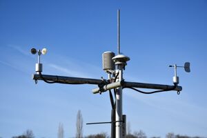
The Maryland Mesonet's mission is to design, build, and operate a network of high-quality, closely spaced, rapid-sampling weather monitoring and data collection systems across the state to advance emergency preparedness, the accuracy of regional weather forecasts, and expedite disaster assessment and recovery.Each mesonet site will measure air temperature, atmospheric pressure, relative humidity, wind speed and direction, solar radiation, rainfall, snow depth, and soil moisture and temperature at five depths, most at 1-minute intervals. The measurements are sent to data servers at the University of Maryland using cellular transmission. The automatic quality-controlled observations are transmitted in near real-time to the National Weather Service and simultaneously available to emergency management personnel and Maryland citizens from the Mesonet website.
Mesonet data will advance community risk assessment and emergency preparedness for impending extreme weather, improve regional weather forecasts by providing more accurate initial states for prediction models, and expedite post-event analysis for disaster declaration and recovery.
LEARN MORE
What does "meso" mean, anyway? In meteorology, "mesoscale" refers to weather events that range in size from 1 to 150 miles in horizontal scale, lasting from several minutes to several hours (e.g., thunderstorms, wind gusts, heat bursts). Mesoscale weather events can go undetected without densely spaced meteorological networks; i.e., they're often too small-scale and high-frequency to be detected by the conventional synoptic observing systems.A mesonet is an observing network built specifically to resolve and monitor mesoscale phenomena:
"Mesoscale" + "Network" = Mesonet!
frequently asked questions history of the maryland mesonet

WHY A MESONET?
An Improved Observation System
The Maryland Mesonet seeks to fill gaps in the federal
observing system by using an array of closely spaced (~10
miles apart) towers equipped for rapid sampling and data
transmission to provide weather forecasters & emergency
management officials with more frequently updated regional
and local weather information.
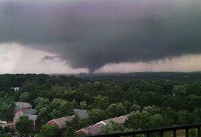
College Park Tornado (9/24/01)
September 2001 saw an F3 tornado move through Prince
George's and Howard Counties, producing heavy damage,
including on the UMD campus. UMD experienced two
fatalities and approximately $15 million in damage,
including tossed trailer classrooms and destroyed
buildings and vehicles.
Wind & Water Emergencies
Many federally declared disasters in Maryland had short lead
times, significantly damaging regional infrastructure and
harming Marylanders, especially those living in small
communities. The Maryland Mesonet seeks to increase the lead
time of extreme weather warnings by monitoring
meteorological conditions at very high space-time
resolution. In some cases (e.g., tornadoes), an increase in
warning lead time of just a few minutes can be
consequential.
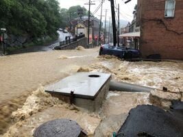
Ellicott City Flash Flood (5/27/18)
A cold front sagged into Maryland, stalling just west of
Baltimore, rapidly producing 6-12 inches of rain. The
rainfall caused catastrophic flash flooding in and around
Ellicott City and Catonsville and stream flooding the next
day, leading to one death and about $11 million in
infrastructure damage.